| | |
The Toolbox is used to use measurements and viewing tools. From the View Menu, select the Toolbox entry (Ctrl + Shift + T) to display the Toolbox. The Toolbox opens as a separate window which you can place anywhere on your screen.
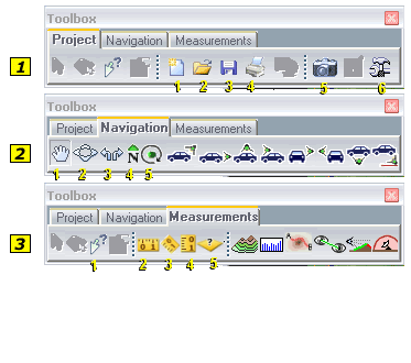
The Toolbox has fourthree tabs with the following options:
|
|
 |
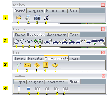
Project - The Toolbox's project tab provides the following set of options:
1. New - Opens a new TerraExplorer Pro project (.Fly file).
2. Open - Opens an existing TerraExplorer Pro project (.Fly file).
3. Save - Saves the existing TerraExplorer Pro project (.Fly file).
4. Prints - Opens a print dialog box for printing the current image in the 3D window.
5. Snapshot - Copies the current 3D View to a floating window.
6. Options - Display the Options dialog box for setting different environment parameters. Click Here for further information on the Options dialog.
1. Open - Opens an existing TerraExplorer Pro project (.Fly file).
2. Prints - Opens a print dialog box for printing the current image in the 3D window.
3. Snapshot - Copies the current 3D View to a floating window.
4. Options - Display the Options dialog box for setting different environment parameters. Click Here for further information on the Options dialog.
|
 |
Navigation - The Navigation tab provides a set of tools you can use for the selected location or object.It also enables you to switch between the different navigation modes:
1. Drag Mode - Select this icon to switch to the Drag navigation mode.
2. Slide Mode - Select this icon to switch to the Slide navigation mode.
3. Turn and Tilt Mode - Select this icon to switch to the Turn and Tilt navigation mode.
4. Face North - Select this icon to have the camera face North.
5. Circle Pattern - Select this icon to start a circle pattern flight around the selected location or object.
View Modes:
From Behind and Above - Select this icon to attach the camera behind and above the selected object (by 45 degrees). This option is enabled only when a static or dynamic object is selected in the Information Window.
Behind Object - Select this icon to attach the camera behind the selected object. This option is enabled only when a static or dynamic object is selected in the Information Window.
Above Object - Select this icon to attach the camera above the selected object. This option is enabled only when a static or dynamic object is selected in the Information Window.
Cockpit View - Select this icon to place the camera at the pivot point of the selected object. This option is enabled only when a static or dynamic object is selected in the Information Window.
From Right - Select this icon to attach the camera to the right side of the selected object. This option is enabled only when a static or dynamic object is selected in the Information Window.
From Left - Select this icon to attach the camera to the left side of the selected object. This option is enabled only when a static or dynamic object is selected in the Information Window.
From Below - Select this icon to attach the camera below the selected object. This option is enabled only when a static or dynamic object is selected in the Information Window.
From Ground Point - Select this icon to set the camera to follow the selected object from a specific location on the terrain. This option is enabled only when a static or dynamic object is selected in the Information Window.
|
 |
Measurements - The Toolbox’s measurements tab provides the following set of tools:
1. Location Tool - Displays the exact location and elevation of a terrain point or display the geographical, geometrical and tabular information of the selected object. The information is displayed in the lower left window.
2. Horizontal Distance Tool - Displays the horizontal distance, elevation difference and slope angle between two or more points in the 3D View.
3. Aerial Distance Tool - Displays the aerial distance, elevation difference and slope angle between two or more points in the 3D View.
4. Vertical Distance Tool - Displays a vertical ruler to measure terrain and objects.
5. Area Tool - Displays the measurement of a horizontal projection of an area in the 3D View.
Contour Map - Opens the properties sheet for displaying the contour map in the 3D View.
(More Info)
Terrain Profile - Displays the terrain profile between two or more points in the 3D View
(More Info)
Best Path - Opens the properties sheet for calculating the best path between two locations in the 3D View. The caluculation is defined by climb and descent slope limits.
(More Info)
Line Of Site - Opens the properties sheet for calculating whether specific locations in the 3D world can be seen from a selected position in the 3D View.
(More Info)
Viewshed Analysis - Opens the properties sheet for calculating the view from any defined viewpoint, along a line or a sector, to an end point in the 3D View.
(More Info)
Threat Dome - Opens the properties sheet for calculating the volume that is visible from a given point in the 3D View.
(More Info)
|
 |
Route - The Toolbox’s route tab provides a set of tools that you can use for the selected route or object. To use the Route tab:
1. Play/Pause - Select this icon to play the activation action for the selected route in the Information Window. If you play a route the icon will switch to Pause mode and you can select it again to pause and play the route flight.
2. Stop - Select this icon to stop the current flight to an object or to stop the current flight to a location. The Stop button also allows you to stop a route in play mode (not enabling it to resume from where it was stopped).
3. Beginning of Route - Select this icon to jump to the first waypoint of a route. This option is enabled only when a route is selected in the Information Window.
4. Rewind - Press and hold this icon to rewind the route. This option is enabled only while a route is played.
5. Fast Forward - Press and hold this icon to fast forward in a route. This option is enabled only while a route is played.
6. End of Route - Select this icon to jump to the last waypoint of the route. This option is enabled only when a route is selected in the Information Window.
|
|
 C2MP
C2MP