Options Options |
 |
|
Graphics:
|
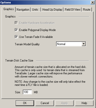
Enable Hardware Acceleration - Select this option to use the power of the 3D video card instead of the software emulation option. Hardware Acceleration should improve your picture quality and frame rate, especially when many objects are placed on the terrain. The Hardware Acceleration feature may not work properly if the appropriate driver for your card is not available.
Enable Polygonal Display Mode - Select this option to take advantage of the new TerraExplorer polygonal display method. When this option is enabled, and the Project supports it, TerraExplorer will use a globe model for the terrain. We recommend that this option is always enabled unless your machine has problems running TerraExplorer with it (i.e., as a result of an old graphic card). If this option is disabled, and you are trying to load a project that forces the polygonal display method, you will be asked if you want to enable it. If you choose not to, the project will not be loaded (see: Project settings for more details).
Use Terrain Fade If Available – Select “Use Terrain Fade If Available” options to get a smoother transition between terrain imagery resolutions in Globe projects. When you open a Globe project, if this option is enabled, TerraExplorer activates a morphing effect that switches resolution. This effect is activated when zooming in or out. When terrain fade is disabled, a new block is displayed on the terrain instantaneously, with no fade.
Terrain Model Quality – Select the resolution of the polygonal terrain model when working with a polygonal project. Select “Normal” for best performances. Select “High” to quadruple the number of polygons used to create the terrain model for the area close to the camera. Select “Best” to quadruple the number of polygons that create the terrain model for the entire visible terrain.
Terrain Disk Cache Size - Among of terrain cache size that is allocated on the hard disk. This cache is only used for terrain data that is streamed from TerraGate. Larger cache size will improve the performance with slower network connection.
|
 |
|
Navigation:
|
Navigation Mode - Select "Slide", "Drag" or "Turn and Tilt" mode for navigating using the mouse in the 3D view.
Tilt affects altitude - When the "Tilt Affect Altitude" option is selected, pointing the camera toward the sky or toward the ground while moving forward will change the altitude of the aircraft.
Follow ground - When this option is selected, the aircraft maintains a constant altitude above the ground.
|
|
Units:
|
Speed:
Km/h - Sets the display units for Speed to Kilometers per hour.
Mph - Sets the display units for speed to Miles per hour.
Knots - Sets the display units for speed to Knots.
Altitude and Distance:
Meters - Sets the display units for altitude and distance to meters. This setting also affects the area measurement display.
Feet - Sets the display units for altitude and distance to feet. This setting also affects the area measurement display.
Altitude Type:
Above Ground (AGL) - Displays altitude values as meters or feet above the ground level in the selected coordinate.
Absolute Values - Displays altitude values as meters or feet above mean sea level.
Lat-Long Coordinates:
Decimal Degrees - TerraExplorer Pro presents coordinate values in a decimal degrees format. This option is only available when the terrain is defined in the Lat/Long coordinate system.
Degrees; Minutes; Seconds - TerraExplorer Pro presents coordinate values in a degrees, minutes and seconds format. This option is only available when the terrain is defined in the Lat/Long coordinate system.
|
|
Head Up Display:
|
Show:
Navigation Controls - Displays Turn and Tilt arrows in the top right area of the 3D Window. Click on the arrows to turn and tilt.
Center Sign - Displays a center sign in the center of the screen. Compass - Displays a small compass, with a North indicator, in the right corner of the screen.
Text - Displays the center sign, speed, altitude and direction in a text form.
Graphic - Displays the complete Heads Up Display in a graphic form.
Colors:
Hud Color - Changes the Head Up Display elements color.
|
|
Field Of View:
|
Camera Field Of View:
The field of view is the size of the camera’s viewing angle, or the zoom level of the camera. TerraExplorer field of view ranges from 15 to 90 degrees, with 53 degrees set as the default. A wider field of view (larger angle) allows you to see more, with a decreased zoom level. A narrower field of view (smaller angle) allows you to see less, with an increased zoom level. In some cases, you will also experience reduced performance of the TerraExplorer application with zoom levels smaller than 53 degrees.
|
|
Route:
|
Viewing Options:
Disable Route Display on Map - Display/hides the path of a route on the Navigation Map whenever that route is selected in the Information Window.
View Route on Terrain - Display/hides the path of a route on the Terrain whenever that route is selected in the Information Window.
Colors:
On Navigation Map - Changes the color of the route line in the Navigation Map window.
On Terrain - Changes the color of the route line in the 3D view.
|
|
|
 C2MP
C2MP