x
We use cookies to analyze traffic and provide you with better content. By continuing to use our site, you agree to the use of cookie technology. Read more. I agree

3D GIS in Support of Disaster Management

When disaster strikes, the team of Skyline Software Systems, WaldoAir and Dewberry can help you work faster and more efficiently to restore order, as well as keep the affected community well-informed of relief efforts and recovery progress. We are proud to support all emergency responders with the information, visualization and analysis tools needed to get help to those in urgent need.

California Wild Fire (November 2018)

In an effort to prioritize recovery efforts, aircrews conducted imagery flights of the affected areas with aircraft specially equipped with WaldoAir’s advanced aerial imaging systems. The high quality imagery collected was then processed using Skyline's Photomesh into 2D True Orthophotos and 3D models of the affected areas. This imagery was integrated with data from various government sources to create interactive maps that cut through the clutter, highlighting essential information including locations of active fires, burned areas susceptible to landslides and mudslides, locations of critical facilities and transportation routes, and locations of at-risk populations.

November 20th, 2018

December 2nd and 4th, 2018

Hurricane Michael (October 2018)

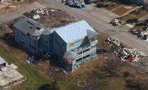
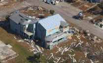
In the aftermath of Hurricane Michael, aircrews conducted multiple imagery flights of the affected areas during the first month with aircraft specially equipped with WaldoAir’s advanced aerial imaging systems. The high quality imagery collected was then processed using Skyline's Photomesh into 2D True Orthophotos and 3D models of the affected areas. This imagery was combined in Skyline's TerraExplorer Pro application with pre-disaster satellite imagery and precise data from Dewberry’s post-hurricane beach survey, enabling easy visualization, classification and analysis of the debris, evaluation of the storm’s impact on the surrounding beach and dunes, and more, thus dramatically speeding up vital damage assessment efforts. Using TerraExplorer and 3 collections over the first month, the team was able to quickly monitor recovery progress, assess follow-up support, and reduce delays in assistance.

October 22nd, 2018

October 30th, 2018

November 12th, 2018

Hurricane Florence (September 2018)

In the wake of Hurricane Florence’s severe flooding of the Carolinas, aircrews conducted imagery flights of the affected areas with aircraft specially equipped with WaldoAir’s advanced aerial imaging systems. The high quality imagery collected was then processed using Skyline's Photomesh into 2D True Orthophotos and 3D models of the affected areas that vastly improved situational awareness by helping to identify critical flooding issues, assess damage to road, dam and bridge infrastructure and individual property, and manage debris.

September 19th, 2018

View all projects with our powerful Desktop Viewer

TerraExplorer for Desktop - Overlay a 3D map with unlimited layers of data creating a 3D high-resolution, geospatial environment that can be analyzed, edited, and shared.

Download TerraExplorer Viewer

Version v7.1.0 for Windows