Menus Menus |
 |
|
File: |
New - Opens a new TerraExplorer Pro project (.Fly file).
Open - Opens an existing TerraExplorer Pro project (.Fly file).
Close - Closes the current project and opens the Start Page.
Save - Saves the existing TerraExplorer Pro project (.Fly file).
Save As - Saves the existing TerraExplorer Pro project (.Fly file) in a new name.
Print - Opens a print dialog box for printing the current image in the 3D window.
Exit - Closes the current project and exit from the application.
|
 |
|
View: |
Toolbox - Opens or closes the toolbox window.
Flight Panel - Opens or closes the flight control panel.
Upper Left Container - Shows or hides the upper left container of the application.
Lower Left Container - Shows or hides the lower left container of the application.
Full Screen - Displays the 3D view in a full screen mode. You can switch to full-screen mode by clicking the Alt-Enter keys. To exit from the full-screen mode click the Alt-Enter or the Esc keys. |
|
Navigation: |
Drag mode - Grip a terrain location and drag it to the left, right forwards and backwards.
Slide Mode - Click and hold the left mouse button on the 3D View. Drag the mouse to the sides to slide forward, backward and to the sides. The speed of the slide is determined by the altitude of the plane and the tilt angle.
Turn and Tilt Mode - Click and hold the left mouse button on any location in the 3D View. The camera will be centered to the selected point of interest. Drag the mouse, while the left button is still pressed, to the eight areas of the 3D View to rotate around and above the center point.
Zoom - Select from one of the available zoom levels: House, Streets, City, State or Globe.
Play - Select this option to activate the default viewing action for the selected object in the Information Window.
Stop - Select this option to finish the automatic flight to/around the selected object.
Pause - Select this option to halt a route pre-defined flight path.
Beginning of Route - Jump to the beginning of the selected route .
End of Route - Jump to the end of the selected route.
View Object - This sub menu allows you to select different flight patterns around the selected object.
Fly Around - Start a flight around the 3D window center point.
Face North - Rotate the camera to face North.
|
|
Measurements: |
Query Information - Displays the exact location and elevation of a terrain point or display the geographical, geometrical and tabular information of the selected object. The information is displayed in the lower left window.
Horizontal Distance - Displays the horizontal distance, elevation difference and slope angle between two or more points in the 3D View.
Aerial Distance - Displays the aerial distance, elevation difference and slope angle between two or more points in the 3D View.
Vertical Distance - Displays a vertical ruler to measure terrain and objects.
Measure Area - Displays the measurement of a horizontal projection of an area in the 3D View.
Contour Map - Opens the properties sheet for displaying the contour map in the 3D View.
(More Info)
Terrain Profile - Displays the terrain profile between two or more points in the 3D View
(More Info)
Best Path - Opens the properties sheet for calculating the best path between two locations in the 3D View. The caluculation is defined by climb and descent slope limits.
(More Info)
Line Of Site - Opens the properties sheet for calculating whether specific locations in the 3D world can be seen from a selected position in the 3D View.
(More Info)
Viewshed Analysis - Opens the properties sheet for calculating the view from any defined viewpoint, along a line or a sector, to an end point in the 3D View.
(More Info)
Threat Dome - Opens the properties sheet for calculating the volume that is visible from a given point in the 3D View.
(More Info)
|
| Tools: |
Collaboration - Allows the user to lead, follow and share in real-time, interactive TerraExplorer fly-through sessions, chat with other users, mark up areas on the terrain, and toggle information layers for further analysis.(*)
GPS Tracking - Tracks real-time objects that use the NMEA standard.(*)
Find Objects - Searches for objects in the projects according to the search criteria.(*)
Free Hand Drawing - Draws lines by tracking the mouse pointer movements.(*)
FalconView Interface - Interfaces to information provided by a FalconView application.(*)
Blue Force Tracking - Tracks real-time objects that use the BFT standard.(*)
Predator Data Feed - Imports Predator feeds and track them using a moving TerraExplorer VideoOnTerrain object.(*)
Navigation Aid - Locks the TerraExplorer camera in 2D modes and continuously tracks the distance and direction to a specific target.(*)
Multiple Coordinate Systems - Projects the current camera/cursor coordinates to a user-selectable coordinate system.(*)
Data Library - Set of Graphic elements you can add to your project.(*)
GPS Tracking - Tracks real-time objects that use the NMEA standard.(*)
GPS Tracking - Tracks real-time objects that use the NMEA standard.(*)
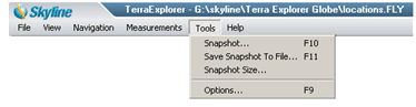
Snapshot - Opens the 3D window view as an image in a popup window which then enables the user to close, save, print or open the image in a paint program or editor.
Save snapshot to file - Opens a popup window to save the image in Bitmap or Tiff file format.
Snapshot Size - Opens a popup window that allows the user to scale the size of the snapshot.
Options - Display the Options dialog box for setting different environment parameters. Click Here for further information on the Options dialog.
(*) - More information available in the tool.
|
|
Help: |
TerraExplorer help topics - Opens the Quick Guide page in the 3D window.
TerraExplorer Home - Opens the TerraExplorer home page in the 3D window.
Flight Instructions - Opens flight keyboard and mouse instructions in the lower left window.
License Manager - View your current license status.
About TerraExplorer - Opens a popup window about TerraExplorer.
|
 C2MP
C2MP